Auf VAVA-U habe ich einen Multiplexer mit W-LAN,
der setzt alle Navidaten von den verschiedenen Gebern an Bord (Wind, Logge, Lot, AIS, GPS usw.) auf NMEA-Daten um und schickt diese per USB und W-LAN an den Bord-PC und mit Hilfe dieser APP auch auf das I-Phone oder das I-Pad.
Die Funktionen habe ich schon ausprobiert und es funktioniert prima.
Wer also ein I-Phone oder I-Pad hat und sich diese APP für ca. € 7,– herunter lädt, kann alle diese NAV-Daten auch bei mir an Bord empfangen. Auf Charterschiffen wird es mangels eines Multiplexer mit W-LAN wohl eher nicht klappen.
Beschreibung des Programmierers:
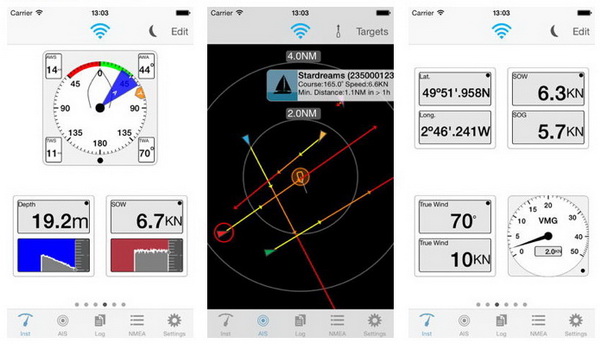
AIS, GPS and instruments for your boat. Essential and useful companion to boat instrumentation or to complement the GPS functions of your device. The app connects through Wifi to NMEA bridges that transmit instrumentation and AIS data. You can configure flexible pages of analog and digital instruments, which display realistic gauges and panels.
● Depth, speed, course, wind, location, rudder, rpm. More instruments in future versions.
The AIS screen shows relative position, speed and course for nearby targets that the on board AIS receiver is reporting. A minimum safe distance can be used to show warnings about potential collisions. The relative direction of travel of targets is shown in colours to indicate relative position in 5, 10 and 20 minutes.
● Relative course and speed, collision detection, forecast position.


Kommentare